|
|

Adrigole Bridge408 views
|
|

Aghista Bridge247 viewsThis medieval Bridge over the Kista stream was part of the original route from Glengarriff to Castletown Berehaven
|
|

Allihies Mines271 viewsDrawing of Allihies Copper Mines made in the mid 1800’s
|
|

Cametringane430 viewsAriel view of Castletownbere taken in 1968. Note the then undeveloped townland of Cametringane on the right.
|
|

Bere Island 329 viewsSlipway, Rerrin, Bere Island. Note the British Warships in the sound
|
|

Rerrin Village, Bere Island. 1903140 views
|
|

Blackrock Terrace. Castletownbere151 viewsP. O’Shea Coach Builder and Michael ??? Shop
|
|

The old road to Castletownbere317 views
|
|

Thatched cottages. Foildarrig144 views
|
|

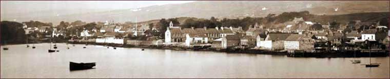
Castletown Berehaven 1905329 viewsCastletown Berehaven in 1905 viewed from the Bay
|
|

Dursey Island257 viewsPloughing on Dursey Island in the 1930's
|
|

The Village300 viewsRerrin Village, East End, Bere Island
|
|

Lord Bantry’s Lodge. Glengarriff185 views
|
|

The Long Tunnel Glengarriff296 views
|
|

The Old Mill. Castletownbere451 views
|
|

The Old Pier294 viewsThe Old Wooden Pier. This photo looking out towards Bere Island with Dinish Island in foreground was taken in the 1930's from the roof of the Church of the Sacred Heart, Castletownbere
|
|
|
|
| Important Notice |
|
All photographs published on this PhotoSite are copyright of Beara Historical Society and the respective photographers.
Heritage PhotoSite images may be copied and downloaded for private use only. None of the material on this site may be copied for commercial use without written permission from the Society.
|